
The ATCOR 4 Method
Basics | Features | Database | Methods | Results
The atmospheric correction of imagery acquired by airborne sensors is an essential part of preprocessing. The objective is to retrieve physical parameters of the earth's surface, i.e. surface reflectance, emissivity, and temperature. This information can be used for monitoring, change detection, surface-vegetation atmosphere transfer (SVAT) modeling, and surface energy balance investigations for climatic modeling and upscaling.
Figures 1 to 3 show a schematic sketch of the radiation components that are taken into account in the ATCOR model:
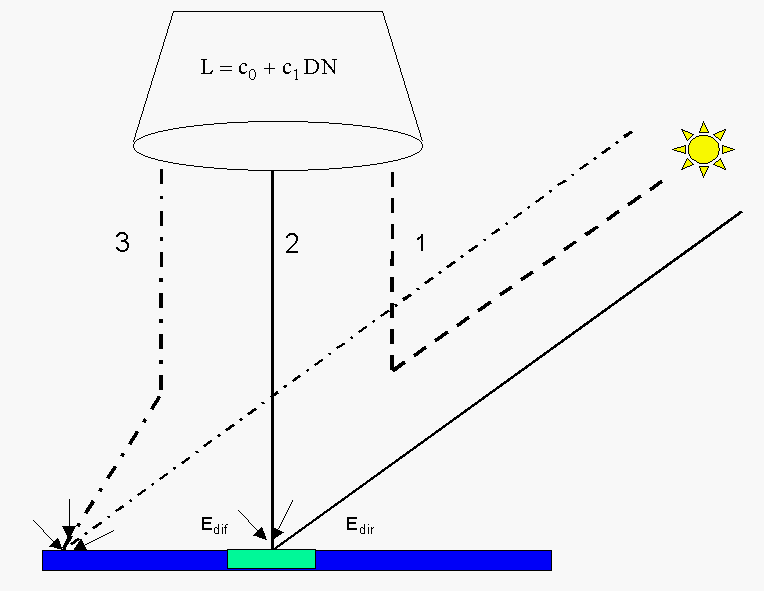
Figure 1 : Schematic sketch of radiation components for a flat terrain (solar region).
Component 1 : path radiance; radiation scattered by the atmosphere
Component 2 : reflected radiation from the viewed pixel (reflected global flux Edir+Edif)
Component 3 : radiation reflected by the neighborhood and scattered into the view direction
(adjacency effect)
Note: only component 2 contains information from the viewed pixel.
DN is the digital number recorded in a certain spectral channel, c0, c1 are the offset and gain of the radiometric calibration relating the DN to the at-sensor radiance L=c0 + c1*DN. The atmospheric correction process removes the signal components 1 and 3 from the total at-sensor radiance L, so radiance component 2 remains. This information is converted into a surface reflectance value.
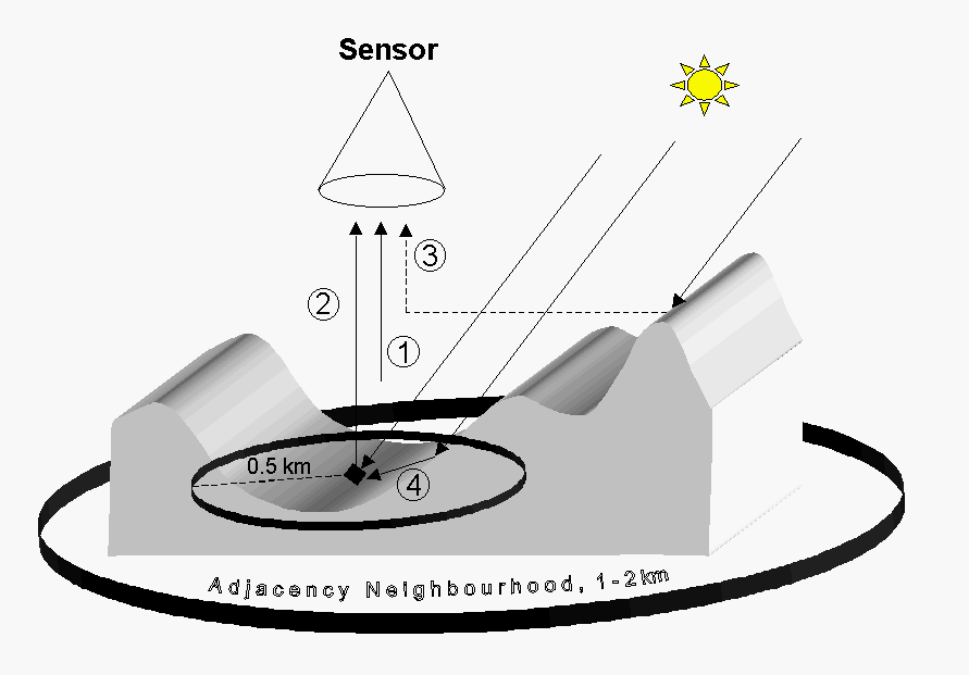
Figure 2: Radiation components: solar region 0.4 - 2.5 um, rugged terrain
Component 1 : path radiance: radiation scattered by the atmosphere
(photons without ground contact).
Component 2 : reflected radiation from the viewed pixel.
Component 3 : adjacency radiation:;ground reflected from the neighborhood
and scattered into the view direction.
Component 4 : terrain radiation reflected to the pixel (from opposite hills,
according to the terrain view factor).
Note: Only component 2 contains information from the viewed pixel.
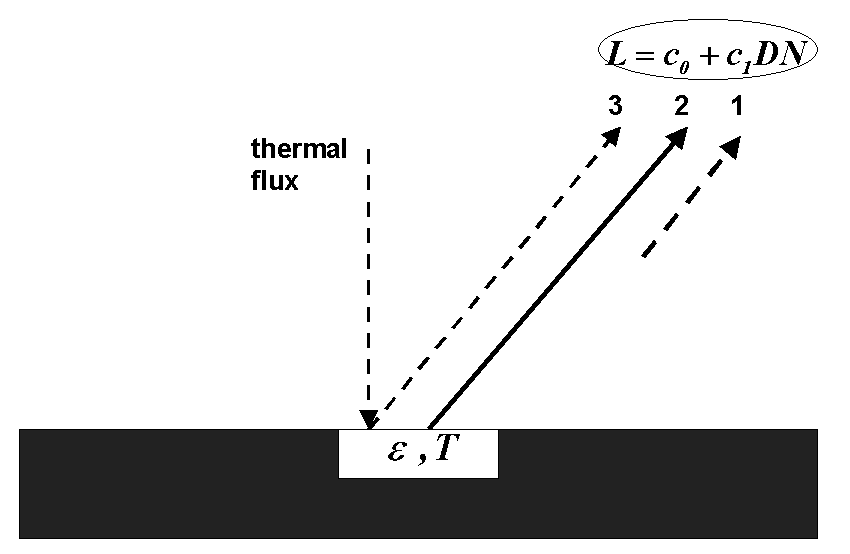
Figure 3: Radiation components: thermal region 8 - 14 um, flat terrain
Component 1 : path radiance; radiation emitted by the atmosphere.
Component 2 : emitted surface radiation from the viewed pixel (emissivity e,
temperature T).
Component 3 : reflected downwelling thermal atmospheric flux F, the reflected
component is L3=r*F/pi,
where r=1-e is the reflectance of the (opaque) surface.
Only component 2 contains the essential information from the viewed pixel.
For a rugged terrain the same three radiation components are considered,
however the elevation-dependence is taken into account. The adjacency effect can
usually be neglected in the thermal region, because the scattering efficiency of
the atmosphere decreases strongly with wavelength.
Sequence of processing steps
The following steps are involved in the atmospheric processing:
- Resampling of required atmospheric files (flight altitudes) from the monochromatic atmospheric database (if new sensor is introduced).
- Geocoding or ortho-rectification (using PARGE), optional for flat terrain.
- For rugged terrain, the slope, and the orientation of DEM pixels have to be calculated, as
well as the sky view factor and cast shadow images
(ray tracing programs for skyview and shadow are included in the distribution) - Before processing the image cube, surface reflectance spectra of small boxes
can be taken from different surface covers in the scene to assess whether the
atmospheric input parameters were appropriate.
A comparison with ground measured spectra or library spectra is supported (SPECTRA module). - If ground reflectance measurements and atmospheric data (radiosonde, visibility, optical depth, or solar irradiance) are available for the scene, an in-flight calibration can be performed to determine the radiometric calibration coefficients (offset and slope of equation relating at-sensor radiance to measured digital number, module INFLIGHT CALIBRATION).
- The atmospheric/topographic correction (ATCOR4) of the image cube is performed based on the assumption of Lambertian surface elements. Visibility and water vapor column can be specified by the user (constant atmospheric conditions) or can be calculated by the program - provided the required spectral bands exist.
- In the case of strong bidirecional effects (viewing in the principal solar plane) an empirical correction method can be selected to normalize the results to nadir reflectance.
An automatic classification of the reflectance cube is possible with the SPECL module that calculates 10-12 surface cover classes based on matching with template spectra.
The following radiative transfer effects are taken into account :
- Rugged terrain: terrain radiation reflected to the pixel (from opposite hills, according to the terrain view factor) is included with 3 iterations (for convergence).
- Adjacency effect: atmospheric crosstalk between adjacent fields of different reflectance. The user specifies the range R of the adjacency effect (typical value R=0.5 km for airborne sensors): iteration step 4 (rugged terrain) or 1 (flat terrain).
- Spherical albedo effect: the global flux on the ground depends on the large-scale (1 km) average reflectance. The global flux in the atmospheric LUT's is calculated for a fixed reflectance=0.15 . Iteration step 5 (rugged) or 2 (flat terrain) accounts for this effect by performing the update for the spatially varying average reflectance map for the current scene, if the adjacency range R > 0 .
- All iterations are skipped if the adjacency range is set to zero (R=0). This may be of interest in studies that assess the influence of radiation components from the surroundings.
- Thermal region: a surface (brightness) temperature image is calculated with
either a user-specified fixed emissivity for a selected thermal band (if multispectral)
or based on an emissivity map derived from an automatic classification of the
reflectance cube (10 - 12 surface cover classes, module SPECL of ATCOR4).
The total radiance consists of path radiance, surface emitted radiance, and the
reflected component of the downwelling thermal flux.
The blackbody surface radiance is calculated for the thermal channels. The surface temperature is obtained using a 2nd order polynomial approximation of the radiance-temperature relationship. The temperature channel is appended as the last band of the cube. Surface emissivity (for multispectral thermal bands) is not provided, but can be calculated from the blackbody surface radiance employing the alpha-residual technique or other methods (user-defined, or as implemented in ENVI). - Bands in the 3-5 um region: not processed because reflected solar and thermal contributions are difficult to separate. These bands are passed directly to the output file.
Accuracy of the Method
The accuracy of the method depends on several factors :
- the radiometric calibration accuracy of the sensor (being typically 3-10%)
- the radiative transfer code; the accuracy of Modtran® 5 is better than 3 % in the atmospheric window regions
- the correct choice of atmospheric input parameters which is user specified
- for near nadir view angles (off-nadir angle < 10 degree), a flat terrain,
and avoiding the specular
and backscattering regions, an accuracy for the retrieval of surface reflectance
of +/-0.02 (reflectance < 0.10) and +/-0.04 (reflectance > 0.40) is possible, see
the Results section .
For larger off-nadir view angles bidirectional effects can play a strong role. For these occasions, the option of nadir normalizing the image is available.
In the thermal region, the surface temperature retrieval additionally depends on the appropriate surface emissivity map. If the deviation of the true surface emissivity from the assumed emissivity is less than 0.02, then the temperatures will be accurate to about 1-1.5 K. Larger deviations will occur if the emissivity estimate is not close to reality. As a rule of thumb, a surface temperature error of about 0.5-0.7 K per 0.01 emissivity error is achieved as long as the surface temperature is much higher than the boundary layer air temperature.
Mountainous Terrain
In the case of mountaineous terrain, the results strongly depend on the quality of the available DEM, and the quality of the ortho-rectification (depending on roll/pitch/heading calibration and GPS flight path information). Large errors can occur in parts of the image (see Publications, Richter 1998 paper in Applied Optics for detailed examples). However, the overall impression of the processed image usually indicates a successful removal of the illumination trends caused by the topography.